


ADVENTURE ON THE RIVER CETINA

Without any doubt, the river Cetina is one
of the nicest places in Croatia where you can experience the magic of
a rafting adventure. It is situated in a luscious region surrounded by
quaint little villages. There are lots of stories surrounding the naming
of this river. Passed down through the centuries several theories on the
naming of the Cetina River have emerged. One possibility is that some
of the first Croatians that came down from Northern Europe towards the
warmer Southern coast, finding the river and naming it Cetina because
it reminded them of the river "Cetynia", in Southern Poland
which was their last Nomadic residence.
A more likely possibility is that the Cetina river derived its name from
the Latin word "Kentona" that was given by tribe Dalmates. Croatians
over time changed this Latin word to Cetina.
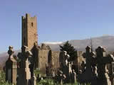
This region is very important, both historically
and archaeologically. Along the Cetina’s tall canyon walls real archaeological
fortune can be found: bottle-axes from the stone-age, shields from roman
soldiers, personal items from middle-age peasants... and many other interesting
artefacts. These findings confirm that people from this region are descended
from an historical-age...
As the years passed by, the surrounding regions Cetinska and Krajina developed.
This area is surrounded by the mountains Svilaja, Kamesnica and Dinara.
This is a very productive region where you can find many small towns and
villages, grasslands and green meadows full of flowers, grass and life.
During moist springs there are many colourful flowers in the meadows and
bees in the air. The Cetina river itself is teaming with life, Supplying
drinking water to much of Dalmatia.
The unusual Climate in this region is a result of its position between the seaside and mountains. The differing climatic influences are visible in the vegetation of the region. The average temperature in January is about 4 degress celcius and in July the average temperature is above 23 degrees celcius. The average rainfall for this region is about 1400mm per year, which highlights the difference between this region compared to Split, and Livno. This is the reason for its sub-Mediterranean climate.
The Cetina river connects many fields and
unites all the waters, both above and below ground. Therefore the Cetina
river gets water from many regions including Livno, Duvno, Kupres and
Glamoc. Therefore the hydrographical territory of Cetina is 3700 square
meters. Just as the Cetina gets water from Bosnian regions, it also gives
away a lot. Therefore colour thrown into Cetina will appear in springs
Studenci, Jadro, and Zrnovnica. As can be seen, Cetina is a very complex
system of hydrological relations and laws. The Cetina’s formation and
intricate underground connections are miraculous! Its length is 105
kilometres and its flow is lower 385 meters when it comes to the Adriatic
Sea from its source.
The source of the Cetina river is situated in a small village (called
Cetina) 7 kilometres away from the town of Vrlika. Gospodarska pecina
(Noble Cave) is situated 100 meters above the source. This cave has important
historical significance as it has been used as shelter for many people
throughout history. During the wars with Turkey local soliders (hajduk)
Socivica hide thre. The Cave is deep but only a small section of it has
been explored. At the end of the 18th century, Ivan Lovrenovic discovered
and described it. He
claims that accompanied by a couple of "Morlaks”, after initially
having trouble
entering the cave they came to a spacious hall ornamented with stalactites
and stalagmites. While listening carefully, he recognized the sound of
underground waters. Following the sound he came to a place he describes
as a "royal underground river". Some people say that this is
the place where underground waters divide to source both the river Krka
and the river Cetina. But who can really understand the secrets of underground
waters?
500 meters down from the start of the Cetina river where the stream is still fairly small, there is a bridge. This bridge has served people for centuries. The bridge has no name, no one knows who built it, or what year it was building. There are many of meadows, green grass and land flowers surrounding the bridge. Resting under a shady tree here listening to the sounds of the river is a wonderful retreat from both people and the hot summer sun. Right there under the bridge (Balecki bridge) is a great place to fish.
On Garjacka kosa, above the river, there are several vineyards. You can find grapes there that are different to all others. They make wine that is sweet and easy to drink. In the beginning of last century, Emperor Franz Joseph (Franjo Josip) came to Krajina, to drink "garjacko" wine. The house where he spent the night is called "Schonbrunn".
Cetina is an entrance to the Sinj fields. There are 60 square meters of fertile ground around town of Sinj, which makes it the biggest field in Dalmatia. There are lots of small towns and villages in that area. In the East are Gala, Otok, Udovicici, Ruda i Grab. In the West are Sinj, Brnaze, Turjaci and Kosute. In the North are Glavice, and in the South are Jabuka and Trilj. In the past after these areas flooded during wintertime, men would bring their animals to this fertile area to pasture. Today, this area is mainly used for corn and wheat.
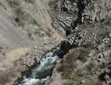
Leaving the Sinj fields, the Cetina river flows into the canyon. Coasts
are closer and higher, and the river is deep and slow. In the past the
water in this area flowed quickly and was used to work mills, however,
a Floodgate has been built which has nade the water slower and deeper.
The floodgate at Djal place, redirects the river and makes the water flow
to the hydro-electririty centre. This is one of three hydro-electririty
centres in the region of Cetinska Krajina. There is a castle Nutjak above
the canyon, which very silently challenges archaeologists and historians.
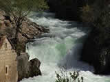
In the town of Omis the river Cetina meets the Sea.
RAFTING ADVENTURE ON THE RIVER CETINA – NEAR OMIŠ
The Rafting adventure begins in the small
town of Omiš. We meet at the intersection
of Omiš’ only bridge on the road that leads towards the picnic area Radmanove
Mlinice. You will be picked up here by a bus or a van (depending on the
number of travellers). You will recognize the van or bus because there
will be oars, life jackets, rubber boats and other rafting equipment on
it. It will also have our Logo and internet address (www.raft.hr).
Rafting trips are organized by our rafting club every day, with departures
at 9am and 2pm from Omiš. We leave Omiš as soon as all tourists have boarded.
The trip to the starting place from rafting takes approwimately 20 minutes.
The journey there is very interesting and allows tourists to see the beauty
of the nature surrounding the river.
5 minutes into our journey to the starting place we come to a picnic area
with a traditional bread - making restaurant called Radmanove
Mlinice. This is actually the end point of our rafting trip. If
tourists have access to their own vehicle then we will pick them up at
this point so that there cars will be waiting for them at the finish.
The bus trip follows a winding road and travels through the woods passing
Quaint traditional Dalmatian villages with overhead views of the river.
The name of the place where we begin our rafting adventure is “Paviæa
Most” (named after an old Roman bridge that is still in use today).
Our starting point has a spacious car park with room for 3 buses and about 15 cars. It also has a typical Dalmatian restaurant called a "konoba", locker rooms and toilets. The start place is easily recognisable as it is signed with flags that have our rafting logo and Internet address. When getting out of the van each tourist takes oars, life jacket and helmet. Skippers will direct tourists to their raft. Each is lead by an experienced rafting skipper. We have the capacity to take 50 tourists at a time, which means we are able to take a hundred rafters per day, 50 in the morning and 50 in the afternoon.
Each skipper along with the crew takes the raft and the
equipment and goes down to the river. We begin trip on a very calm spot
on the river. Once everyone is seated on the boat the skipper explains
to the crew how to row, what to do if they fall into the river where it's
calm and what to do in the rapids. The skipper will always check if everyone
in the boat can swim. (This is a very reasonable question). The first
16 kilometres of the river is a part where the river is very calm, the
scenery is gorgeous and the water is crystal clear and clean. The river
is full of fish and several people camp along the shore.
During this initial section of the river, the crew is practicing correct
rowing and following directions that will later be required.
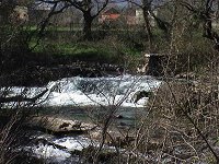
We then pass through to sections of the river where the trees have overgrown and formed tunnels. This is the section of the river that is very technically demanding, so the crew must follow all instructions carefully. This section of the river is called the "labyrinth". We will then come to a small lake-like expanse of water where we take a break for about 10 minutes, so rafters can go swimming and refresh in the clear blue-green river.
The next place we stop is at a small floodgate where tourists can taste the fresh clean wayer running from a small stream. From that place, the next couple of kilometres is the best part of rafting on the river Cetina. First only children on the toboggan go down, the made on the river especially for rafting and right after that we come to the bottom of the small waterfall "Studenci", one of the most beautiful waterfalls on the river Cetina. You will be photographed on the toboggan and under the waterfall by a local photographer. These photographs will be available for purchase in big format for 15 kuna’s at finish point Radmanove Mlinice. The Waterfall "Studenci" is definitely something that has to be seen! After the waterfall comes the beautiful and very dangerous rapid "Oblacnik". Tourists exit the raft at this point and travel along the river edge for 50 metres while the sjkipper manouvers through the rapid “Oblacnik”. Tourists return to the boat and the adventure continues.
After 2-3 minutes we come to two other smaller waterfalls.
We travel under one of the waterfalls for some fun.
Then we come to some very interesting rapids, called "Z".
It's very important to listen to all the skipper's
instruction at this point, otherwise you could fall out of the boat! "Z"
is a place where your adrenaline is at its’ highest level. Coming to the
part of the river called "Tisne stine"
as the river is fairly deep at this point tourists can jump into the river
from rocks that are 3 meters above the river. Not far away, after we pass
through another 5-6 rapids, we come to the place where they filmed the
final scene of a famous American western film "Winetou". This
location is a paradise for rock climbers and it is a possibility that
people who love this sport can come in the morning and then leave with
the afternoon group. In the last 25 minutes there are a couple of rapids
and then rafting adventure finishes t the picnic place called Radmanove
Mlinice. All equipment (helmets, oars, life jackets) are left on the boat
while the raft is carried by everyone to the shore. That's where the photographer
waits for the rafters with developed pictures. Club "Rafting"
will return you to Omiš in a van or a minibus. Rafting on the river Cetina
is an adventure that lasts between 3 and 4 hours, although you will we
are sure you will talk about it for years (and when you show the pictures
to everyone back home they will all envy you).
Most tourists are impressed by the beautiful Cetina river. The adrenalin
that the adventure gives you will hopefully entice you to return as soon
as they get some more free time. We hope to see you soon…